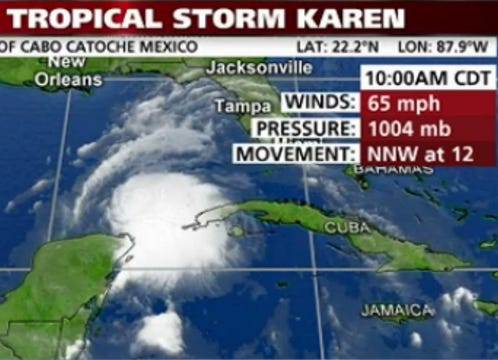
Tropical Storm Karen update 12:54 CDT
· There is still uncertainty in the current forecast. Tropical Storm Karen is expected to make landfall as a moderate tropic storm or category 1 hurricane. At this time, Santa Rosa County is in the cone of uncertainty.
· Weather is expected to begin deteriorating Friday, Oct. 4. Tropical storm force wind gusts are anticipated to reach Santa Rosa County on Friday evening with possible sustained tropical storm force winds beginning Saturday afternoon.
· Three to five inches of rain expected Friday through Sunday with a possible six to eight inches in localized areas. Flooding of low lying areas and smaller stream basins possible. Large river basins may see minor flooding.
· The marine area is expected to experience possible 40 to 50 mph winds late Friday night into Saturday morning.
· Coastal flooding on beach areas could reach two to four feet inundation flooding over land. Tide levels three to five feet above normal tide levels starting late Friday into Saturday. See NWS slide explaining storm surge at www.santarosa.fl.gov/hurricanecenter/documents/NWS%20Strom%20Surge%20Info.pdf
· Expect a HIGH RISK FOR DANGEROUS RIP CURRENTS Friday into Saturday. Also beach erosion with higher wave run-up possible Friday into Saturday. High tide will be during the evening hours.
Steps Residents Can Take Now
· Clear your yard of any debris that might clog stormwater drains when washed to the street by rain such as leaves or limbs.
· Turn off any automatic sprinkler systems and do not water your lawn until after the storm passes.
· No evacuation orders are currently in effect, however this can change depending on changes to the storm’s forecasted track and impacts to Santa Rosa County. Don’t wait to find out if you live in an evacuation zone, visit www.santarosa.fl.gov/gis and enter your address or download the “B-ready Santa Rosa” app from the iTunes or Google Play store.
· Fill vehicle gas tank.
· Get cash and secure important papers and valuables.
· Refill medications.
· Bring in outdoor objects such as lawn furniture, toys and garden tools.
· Shutter your windows.
· Prepare boats.
· Help neighbors with their preparations.
· Make final preparations to secure your home so you can leave if an evacuation order is issued.
· No shelters are currently scheduled to open. However, if you are registered for transportation to a public shelter, be sure you have everything you need for your “go bag” in case conditions change.
· Santa Rosa County Division of Emergency Management’s latest all-hazards disaster guide is now available online at http://www.santarosa.fl.gov/news/factsheet/2013%20Disaster%20Guide.pdf or at county offices and libraries, local chambers of commerce, and local retailers.
Actions Taken by Santa Rosa County
· The Santa Rosa Commission will have an emergency called meeting on Friday, Oct. 4 at 9 a.m. in the emergency operations center located at 4499 Pine Forest Road in Milton to discuss any needed board action. The meeting is open to the public.
· Emergency management staff are participating in planning meetings today and will be monitoring conditions overnight.
· Public works crews have implemented their storm preparation protocol which includes fueling of equipment, stocking vehicles, placing employees on standby for after-hours road clearing, staging equipment, and clearing of all known blocked drainage features.
· The Citizens Information Line is open at (850) 983-INFO (4636).
· The American Red Cross is on standby to open a public shelter if needed.
· County offices will operate as normally scheduled.
Sand & Bags
Sand and sand bags are available at local home improvement stores for purchase. Santa Rosa County is making limited supplies available at no cost at several locations. Residents should bring shovels and be prepared to fill and load their own bags. County and fire department staff ARE NOT available to make home deliveries. If fire department staff are on calls, they will not be available to hand out sand bags.
· Sand only is available at the following locations while supplies last.
– Tiger Point Park-1370 Tiger Park Lane, Gulf Breeze
– The intersection of Citrus Drive and Leisure Street in Holley By The Sea
– The intersection of Pine Forest Road and Carroll Road in Milton
· Empty Sandbags (25-bag limit per vehicle) while supplies last at:
– From 7 a.m. to 7 p.m. at Midway Fire District Station at 1322 College Pkwy.
– Beginning Friday, Oct. 4 at 8 a.m. at Gulf Breeze City Hall,1070 Shoreline Dr., Gulf Breeze
· Sand & Sandbags (25-bag limit per vehicle) while supplies last at:
– Pace Fire Rescue District at 4773 Pace Patriot Blvd.
– Holley-Navarre Fire District at 8618 East Esplanade St.
Traffic Conditions
General Safety Information
Citizen Information Line
This article originally appeared on Santa Rosa Press Gazette: Santa Rosa County offers update on T.S. Karen
