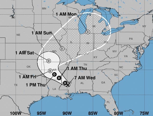
UPDATE: Santa Roa county provided this current information on the response to the coming tropical storm Gordon.
Storm Information:
-
Flooding remains a concern as Gordon moves from our area – both flash flooding, coastal flooding and possible flooding of low-lying bridges. Remember not to cross roads or bridges covered in water. Turn around, don't drown!
-
Road closures will be posted online.
-
No major issues have reported at this time. There was no damage reported from the tornadoes that passed over our area last evening. If you experienced any damage at your home, complete our online damage assessment form.
Local Actions
-
All county offices, schools and the pier are open with normal hours.
-
All county roads and bridges are open.
UPDATE: Santa Roa county provided this current information on the response to the coming tropical storm Gordon.
Local Actions
-
Santa Rosa County Tax Collector's Office will close at noon.
-
Santa Rosa County has made limited supplies of sand available at no cost at several locations. Sand bags can be purchased for less than 50 cents each at local hardware stores. Bring shovels to fill and load your own bags. Those locations are Leisure Street at Citrus Drive in Holley By the Sea, Tiger Point Park in Gulf Breeze, Pace Fire-Rescue in Pace and the corner of Pine Forest Road and Carroll Road in Milton.
-
Double red flags are currently flying at the beach which means the beach is closed to swimmers.
Closures
-
The Gulf Islands National Seashore has closed the Fort Pickens and Perdido Key areas as well as the Opal Beach day use area. Park status updates are posted online at www.nps.gov/GulfIslands. The Naval Live Oaks area will remain on its normal operating schedule at this time, but the status may change with conditions.
-
Pensacola State College has closed all campuses, offices and non-essential functions. All campuses will reopen Wed., Sept. 5.
See the previous update below.
MILTON — Santa Rosa County provided this Tropical Storm Gordon update from the National Weather Service:
-
Tropical storm force winds are anticipated to reach Santa Rosa County Tuesday early evening.
-
An isolated tornado or waterspout cannot be ruled out.
-
Rainfall amounts are expected to be relatively low with one to three inches over the next 48 hours.
-
Storm surge is expected to be two to four feet above normal.
-
Emergency management staff will be monitoring Gordon overnight and tomorrow (Tues.).
Local Actions
-
Santa Rosa County schools will close for a half day, all after-school activities to include community school/latch key kid program will also be closed. Schools will resume as scheduled on Wed., Sept. 5.
-
No evacuations have been ordered and no shelters will be opened at this time.
-
Central Landfill in Milton will be open for regular hours. Waste Pro will run regular routes tomorrow (Tues.). If they must stop due to inclement weather, they will finish routes Wed. morning. For any questions regarding trash pickup, call your waste hauler.
-
County offices and the court system will operate as normally scheduled on Tues., Sept. 4.
-
Bridges will be monitored law enforcement throughout the event and closed as necessary. NO BRIDGES ARE CLOSED IN ADVANCE OF A STORM.
-
The biggest threat for our area remains to be an extremely high risk of life-threatening rip currents. Knee-deep is too deep. Abide by the flag warning system and lifeguard instruction. Red flags are currently flying at the beach which indicates a high risk of rip currents. Double red flags mean the beach is closed to swimmers.
General Safety Information
-
Emergency Management web site: www.santarosa.fl.gov/emergency
-
Facebook: www.facebook.com/SRCEmergencyManagement
-
Monitor your home weather radio and local media outlets for the most up-to-date information. Your best defense in any disaster is a NOAA Weather radio.
-
Subscribe to AlertSantaRosa.com for emergency updates, including possible road and bridge closures.

This article originally appeared on Santa Rosa Press Gazette: Flooding remains a threat as storm passes
